
Twin Satellites Rewrite Hurricane Forecasts
The ocean has a memory, and it is written in inches. For more than three decades, a lineage of spaceborne instruments has tracked the subtle rise and fall of sea levels, a record that now faces its most consequential test yet. A historic El Nino is unfolding, and for the first time, two identical satellites are flying in tandem, 30 seconds apart, to capture it. The data they are collecting feeds directly into the algorithms that decide when to evacuate a coastline. The challenge has always been that the ocean’s heat, the fuel for the most destructive storms, is invisible to the naked eye and largely hidden from traditional weather satellites. These twin sentinels measure the ocean’s surface height with such precision that they can map the hidden heat that determines whether a tropical storm becomes a catastrophic hurricane.
The current event is a late-bloomer, says Josh Willis, Sentinel-6B’s project scientist at NASA’s Jet Propulsion Laboratory in Southern California. [1] The El Nino did not kick off until the middle of the year, and it is only now reaching a strength similar to what the satellite record shows for the significant events of 1997 and 2015. [1] Forecasters expect it to grow large, and it is already reshaping global weather patterns. Normally, the warmest ocean waters sit along the equator in the western Pacific. During an El Nino, the weakened winds that usually blow westward along the equator allow that heat to spread eastward, toward the coast of South America. This redistribution of heat in the ocean directly affects sea level, which is precisely what the satellites are designed to measure with unmatched accuracy.
The shift in ocean heat has a direct and powerful consequence: it moves the primary stage for hurricane activity. The change in sea surface temperatures scrambles weather patterns tied to rainfall and storms, and it shifts the focus of hurricane formation from the Atlantic Ocean to the Pacific Ocean. Understanding the ocean’s heat content therefore determines where the next major storm will strike. The two satellites, part of the Copernicus Sentinel-6/Jason-CS mission, are the latest in a series of ocean-observing radar altimetry missions that have been monitoring Earth’s changing seas continuously since the early 1990s. They are the direct descendants of a legacy that began with the TOPEX/Poseidon mission, which launched in 1992, and their job is to ensure that this precise dataset extends deep into its fourth decade.
The Heat Hidden Beneath the Waves
The key to predicting a hurricane’s strength lies not in the wind or the clouds, but in the thermal energy stored deep within the ocean. A hurricane acts like a heat engine, drawing its power from warm surface waters. The warmer the water, the more energy is available for the storm to intensify, sometimes with terrifying speed. A tropical storm can take a week or more to become a hurricane and make its way to a coastline, but a hurricane can rapidly intensify in the 48 hours prior to landfall, leaving planners little time to prepare. The instruments on the Sentinel-6 satellites are designed to see this fuel source, measuring ocean height, wave size, and marine wind speed using a radar altimeter that bounces thousands of radar pulses a second off the crests and troughs of waves.
The science behind this measurement is elegant in its simplicity. Ocean height varies from place to place, and these variations provide direct insight into the ocean’s heat content, since warm water expands. This expansion is minuscule, but over the vast expanse of an ocean basin, it creates a measurable slope on the water’s surface. The radar altimeter can detect these differences in height with incredible precision, allowing scientists to create a map of the ocean’s internal heat. Deirdre Byrne, an oceanographer and altimetry expert with the National Oceanic and Atmospheric Administration, explains that the goal is to forecast how much and how rapidly intensification will happen so that officials can make the right calls. [4] She oversees one of the country’s most crucial hurricane forecasting algorithms, NOAA’s Satellite Ocean Heat Content Suite, which has been operating since 2012.
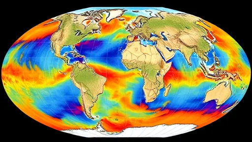
Byrne describes the data quality from the Sentinel-6 missions as unparalleled. [4] This is not just a matter of having a new satellite; it is about the consistency of the measurement. The satellites each carry a second instrument, called the Global Navigation Satellite System - Radio Occultation, which measures atmospheric properties such as humidity, pressure, and temperature. This combination of ocean surface data and atmospheric profiles gives forecasters a three-dimensional view of the storm environment. The radar altimeter is the primary tool for measuring the ocean’s heat, but the radio occultation instrument provides the atmospheric context, showing how the storm is interacting with the moisture and temperature of the air above the sea.
The practical application of this data is already in motion. On July 15, Sentinel-6B began delivering low-latency data to scientists that could be used for weather predictions. [2] This data feeds directly into hurricane tracking algorithms used by federal and state agencies, providing the crucial information needed for disaster response. The predictions that result from these models can activate disaster response efforts, mobilizing resources ranging from sandbag placement to National Guard activation. They also can lead to evacuation orders that require quick but well-informed decisions about logistics at a local level. More severe events may require engaging larger organizations, such as the Federal Emergency Management Agency, to coordinate a large-scale response.
The Long View of a Changing Ocean
The true power of the Sentinel-6 mission lies not in its advanced technology alone, but in its role as the guardian of a long-term record. The mission is designed to provide continuity, ensuring that the precise dataset of sea level observations that began with TOPEX/Poseidon in 1992 continues without interruption. This continuity is what allows scientists to distinguish a single, dramatic El Nino event from the long-term, underlying trend of sea level rise. Without a consistent reference, it would be impossible to tell if the ocean is changing because of a seasonal shift in currents or because of a decades-long trend in global warming. The key is consistency, measuring the same way, every time, according to Severine Fournier, Sentinel-6B deputy project scientist at JPL. [1]
The two satellites are working together to ensure this consistency. Sentinel-6B is now flying 30 seconds behind its predecessor, Sentinel-6 Michael Freilich, named after a former director of NASA’s Earth Science Division. This close formation allows the two instruments to cross-calibrate, ensuring that their measurements are perfectly aligned. Sentinel-6B will eventually take over for its predecessor as the reference satellite for global sea level measurements later this year. This handover is a critical moment, as it ensures the continuity of the dataset without a gap. The satellites are providing precise sea level height measurements during what oceanographers expect to be a historic El Nino, a naturally occurring oceanic phenomenon in which warmer-than-usual Pacific waters shift global weather patterns.
The mission itself is a testament to international collaboration, jointly developed by the European Space Agency, EUMETSAT, NASA, and NOAA, with funding support from the European Commission and technical support from the French space agency CNES. [2] This partnership is a recognition that the ocean is a global system that no single nation can monitor alone. The data from these satellites is used by scientists and forecasters around the world, and the infrastructure that supports them is a shared responsibility. Spacecraft monitoring and control, as well as the processing of all the altimeter science data, is carried out by EUMETSAT on behalf of the European Union’s Copernicus Programme, with the support of all partner agencies. [3]
The limitations of this approach are defined by the physics of the measurement itself. The radar altimeter measures the height of the sea surface, which is a proxy for heat content, but it does not measure the temperature at depth directly. The data must be interpreted through models that convert sea surface height into an estimate of the ocean’s thermal energy. This is a sophisticated process, but it is not a perfect one. The ocean is a complex, layered system, and the relationship between surface height and deep heat can be influenced by other factors, such as salinity and ocean currents. The satellites provide a critical piece of the puzzle, but they are one part of a larger observing system that includes buoys, ships, and other instruments.
The data now being collected will sharpen hurricane predictions for years to come. That sharper forecasting protects coastal communities and infrastructure. The record of sea level observations, now extending into its fourth decade, provides a baseline against which all future changes can be measured. This is the true legacy of the Sentinel-6 mission: not just a snapshot of a single event, but a continuous, precise, and reliable record of the planet’s changing seas. The data will take time to reach the research models that meteorologists and climate scientists rely on, but once it does, those improved models could save lives.
Sources
1. NASA’s Jet Propulsion Laboratory
3. EUMETSAT
4. NASA
6. CNES